We are supposed to mention ocean currents effecting Michigan, i haven't gotten that far yet but i found some good information on Lake Effect Snow. A few things effect lake effect snow, (i know this is a little off topic but i though it was kind of interesting to know) the position of the storm tracks, the degree and variations in lake water temperatures, the extent of ice coverage,prevailing wind directions and the frequency of strong wind speeds. Lake effect snow effects everywhere in Michigan. so here is the ocean current information. An ocean current is continuous, directed movement of ocean water. Ocean currents are rivers of hot or cold water within the ocean. The currents are generated from the forces acting upon the water like the planet rotation, the wind, the temperature and salinity (hence isopyncal) differences and the gravitation of the moon. The areas of surface ocean currents move somewhat with the seasons; this is most notable in equatorial currents.
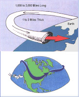
So now she wants us to include information on the jetstream and why it could be causing our crappy weather.Jet streams are fast flowing, relatively narrow air currents found in the atmosphere around 10 kilometers above the surface of the Earth. They form at the boundaries of adjacent air masses with significant differences in temperature, such as the polar region and the warmer air to the south. The major jet streams are westerly winds (flowing west to east) in the Northern Hemisphere, although in the summer, easterly jets can form in tropical regions. The path of the jet typically has a meandering shape, and these meanders themselves propagate east, at lower speeds than that of the actual wind within the flow. n general, winds are strongest just under the tropopause (except during tornadoes,hurricanes or other anomalous situations). If two air masses of different temperatures meet, the resulting pressure difference (which causes wind) is highest along the interface. The wind does not flow directly from the hot to the cold area, but is deflected by the Coriolios Effect and flows along the boundary of the two air masses. I think that is all that i had to do this was a little harder than before. Have a good day everybody. Think GREEN!!!

 Britt
Britthttp://www.islandnet.com/~see/weather/elements/lkefsnw3.htm
http://en.wikipedia.org/wiki/Ocean_currents
http://en.wikipedia.org/wiki/Jetstream

1 comment:
Excellent reflections with researched explanations.
Post a Comment